Noyac’s Rich History
The Old Indian Village of Noyack
Excerpted from the Sag Harbor Historical Society

The use of “the Old Village of Noyack” has been cut short today to “Noyac.” Noyack with the “k” best reflects the place’s Indian heritage. The word “Noyack” is of Indian origin and signifies “a point or cornerof land,” which Indians used to describe the long neck of land called “Farrington’s Point” in early Southampton Town Records. Later the peninsula was named “Jessup’s Neck,” which today we know as Morton Wildlife Sanctuary.
Memories of Noyack’s Indian History...
Noyac was once – over 100 years ago – an Indian village, but all signs of its original character have disappeared, except that old Indian arrow heads are frequently dug up on the farm lands. – Brooklyn Sojourner, Brooklyn Daily Eagle.

Bob Graham
George McAuliffe is among those who, years ago, found a couple of perfect Indian arrow heads. He believes that Indians chipped them up there in the hillsas he also found chips and shell mounds.
Bob Graham, the hermit of Trout Pond, spent more time studying the woods around Trout Pond than most Noyackers and often wrote about them in his Sag Harbor Express column, “Noyac Notes.” ...“I too have heard of Indians living in the hollow where the Trout Pond is, and not long ago, I ran across what looks like an Indian grave at the back of the pond, marked out with the usual covering of stones.” – April 20, 1954.
The “Bard of Noyac” Russell P. Edwards (1887–1963), recalled a childhood memory when interviewed in the Sag Harbor Express, February 2, 1956. “Relaxed in an easy chair in the big living room, at home among solid furniture which seems to have grown into the house, under the hand hewn beams of another era, one may find ‘The Patriarch of Noyac’ reading away the quiet hours of a winter evening.…Mr. Edwards remembers when the last Indians lived in a teepee back of the Mill Pond. They were basket weavers, and he met them at his grandfather’s home.” Unfortunately, more was not recorded in this interview.
Houses now replace former Indian encampments; Wickatuck Spring was filled in, and William
Wallace Tooker’s plaque marking the place was stollen. Preservation and care for remaining open land around Trout Pond will protect rare evidence of Indian and white men’s settlements.
Legendary Weckatuck Spring
Excerpted from the Sag Harbor Historical Society

Weckatuck– This name is susceptible of two interpretations:
• weque-tugk: “end of the woods or trees” or
• weque-tuk: “end of the cove or creek”
– William Wallace Tooker, Algonkinist
Once, Weckatuck Spring, located overlooking bountiful and beautiful Noyack Bay and the Sag Harbor Coves, was the peaceful gathering place for Shinnecock and Montauk Indians. After European settlement, fishermen, sojourners, and Bliss Torpedo testers availed themselves of Weckatuck’s pure spring water.
Few people are left with us who found arrow heads and shell mounds, and remember when Weckatuck Spring flowed – the physical reminders of the Indians’ presence. In 1893, W.W. Tooker went to the well-known spring at Long Beach and carved the name “Weekatuck, 1637–1893” on a stone nearby. Now that the land has been developed, Tooker’s stone is lost and the spring filled in. All that remains is the history of the Shinnecocks’ presence and the Legends of Weckatuck Spring. They must be preserved.
Stories are told of young Indians who met at Weckatuck Spring, tribal alliances, canoes launched with its sacred water by the hand of a maiden to ensure luck in fishing, sports, war, and to make its owner invulnerable to all adversity. The story of its healing water is the most repeated of these legends. Tiana, an ancient Indian woman herbalist living near the spring, was called on when a deadly malady stuck the Montauketts taking men, women, children, and their leader. She gathered herbs, drew water from Weckatuck Spring and paddled alone to Montauk, where she treated the sick and gave comfort to those who had lost their dear ones. Her presence helped to relieve their terror.
Continental Soldiers Landed in Noyac to Attack the British
by Jim Marquardt; Sources: Wikipedia, etc.
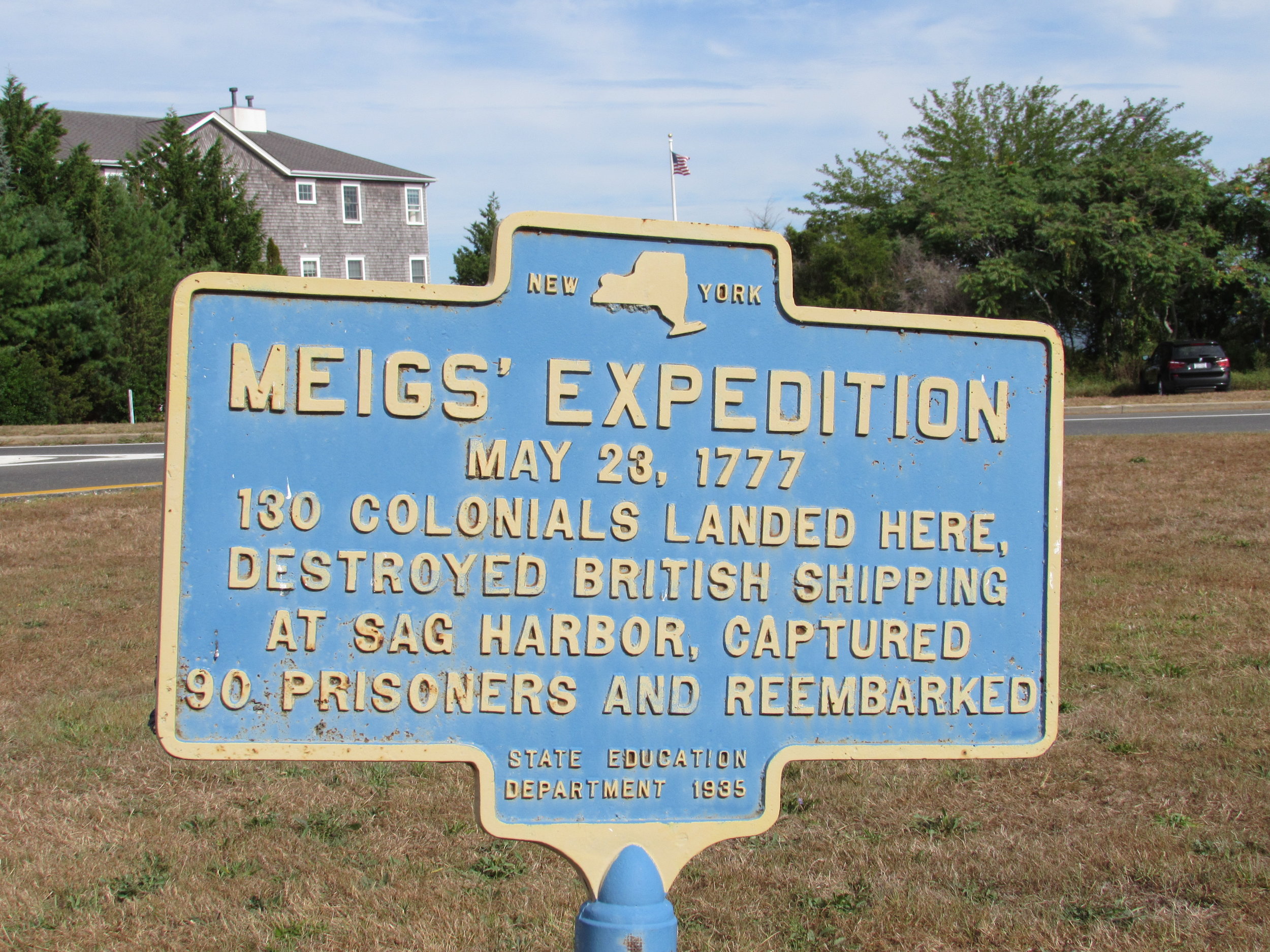
The early days of the Revolutionary War were bleak for the rebel cause against England, especially for patriots in the State of New York. By the winter of 1776 the British Army had consolidated its hold on all of Long Island and New York City. So it was a huge boost to American morale when in May, 1777, Colonel Return Jonathan Meigs led soldiers of the Continental Army in an attack on
the British on the East End. In the company of armed sloops, Meigs’ men sailed across Long Island Sound from Guilford, Connecticut, landing in the vicinity of Southold. They dragged eleven whaleboats over the North Fork to Noyac Bay where 130 men of the company rowed across to what is now the hamlet of Noyac. From there, before dawn, they marched to Sag Harbor and attacked
British Loyalists who were foraging for munitions and supplies. In an outstanding feat of arms, the Americans killed six of the enemy and captured 90 others without the loss of a single man.
Continental Army General Samuel Holden Parsons planned the raid in retaliation for a British attack on Danbury in April. He also recognized the importance of Sag Harbor as a supply base for the Royal Navy which was patrolling the eastern end of Long Island Sound from an anchorage in Gardiner’s Bay. A battalion of 70 English Loyalists manned a fortification on Meeting House Hill, while a 12-gun schooner protected a 40-man foraging party and their boats in the harbor.
Meigs’ divided his men into two strike forces, one to storm the fort, the other to attack British vessels at their moorings. The assault on the fort was carried out silently with fixed bayonets. British guns on the schooner opened fire but failed to stop Meigs men from destroying twelve British boats and their cargos in the harbor. Meigs raiders took 53 prisoners at the fort and another 37 at the wharf without losing a man.
Historical accounts don’t describe the American withdrawal to Connecticut. Presumably they marched back to Noyac with their 90 prisoners, crammed everyone onto the whaleboats, ferried across Noyac Bay and again portaged overland to meet support boats in the Sound. The Second Continental Congress presented Return Jonathan Meigs with a ceremonial sword in recognition of his courageous victory during the dark days of the war.

Trout Pond Preserve
Excerpted From Trail Guide to the South Fork by Mike Bottini
The forty acres of woods and freshwater wetlands that comprise Trout Pond Town Park are nestled between the estuarine waters of Mill Creek and Noyac Bay to the north and a ridge of glacial deposits, known as the Ronkonkoma moraine, to the south. Trout Pond is fed by two small brooks that appear, somewhat magically, out of the ground just north of Ruggs Path. Meandering through a diverse forest, the brooks lose 15 feet of altitude before reaching the pond where, at the north end, a spillway over the dam drops another ten feet en route to the tidal waters of Mill Creek. Long a favorite swimming hole for nearby neighbors, in the 1970s town officials began exploring sources of funding to acquire the pond. In 1983, following a town-wide referendum on the matter, the pond and thirty three adjacent acres were purchased to create Trout Pond Town Park.
Before colonial times, an unimpeded creek known as Noyac River flowed through this narrow, steep-sided valley and into Noyac Bay. “Noyac” is the Native American term for “point or corner of land” which, according to William D. Halsey, author of Sketches from Local History, refers to nearby Jessups Neck, one of the most prominent natural features in the area. The close proximity of abundant shellfish, in addition to the excellent supply of freshwater, made Noyac River an ideal summer encampment for a small band of Native Americans who were most likely part of the Shinnecock tribe. In fact, present-day Noyac Road closely follows the pre-colonial Indian route between here and the main Shinnecock settlement in Southampton Village. According to William D. Halsey, evidence of the Native American encampment was clearly visible as recently as the 1960s.
Town historian Robert Keene put the date of the first earth and stone dam sometime in the early 1700s, creating what was then called Mill Pond to power a grist mill. Prior to that (1686), a fulling mill was operated on “the stream at Noyack”; apparently this type of mill could be operated without a dam. The grist mill was owned by Charles Rugg, for which nearby Ruggs Path was named. At one time a windmill was constructed to pump water back uphill and into the pond. Various mills were operated until 1881, when heavy rains overtopped the dam and caused considerable damage. The dam and stone bridge over which Noyac Road crossed were repaired, but not the mill.
The property was then acquired by George Thompson who stocked the pond with trout, changed its name to Oak Grove Trout Pond, and ran a resort out of a house built near the pond’s south end. In 1905, F. E. Mellinger bought the pond and surrounding lands to raise ducks and pigeons (squabs). At one time there were 5,000 pigeons here before a forest fire swept through the area. At least one of the pigeon coops was salvaged and transported to the Hendrickson farm on Lumber Lane in Bridgehampton, where it served many years as a chicken coop. The concrete foundation of the coops can still be seen just south of Ruggs Path.
The preserve’s trails provide access to a wide variety of plant communities including a red maple – tupelo swamp that attracts lots of interesting wood warblers during spring migration.
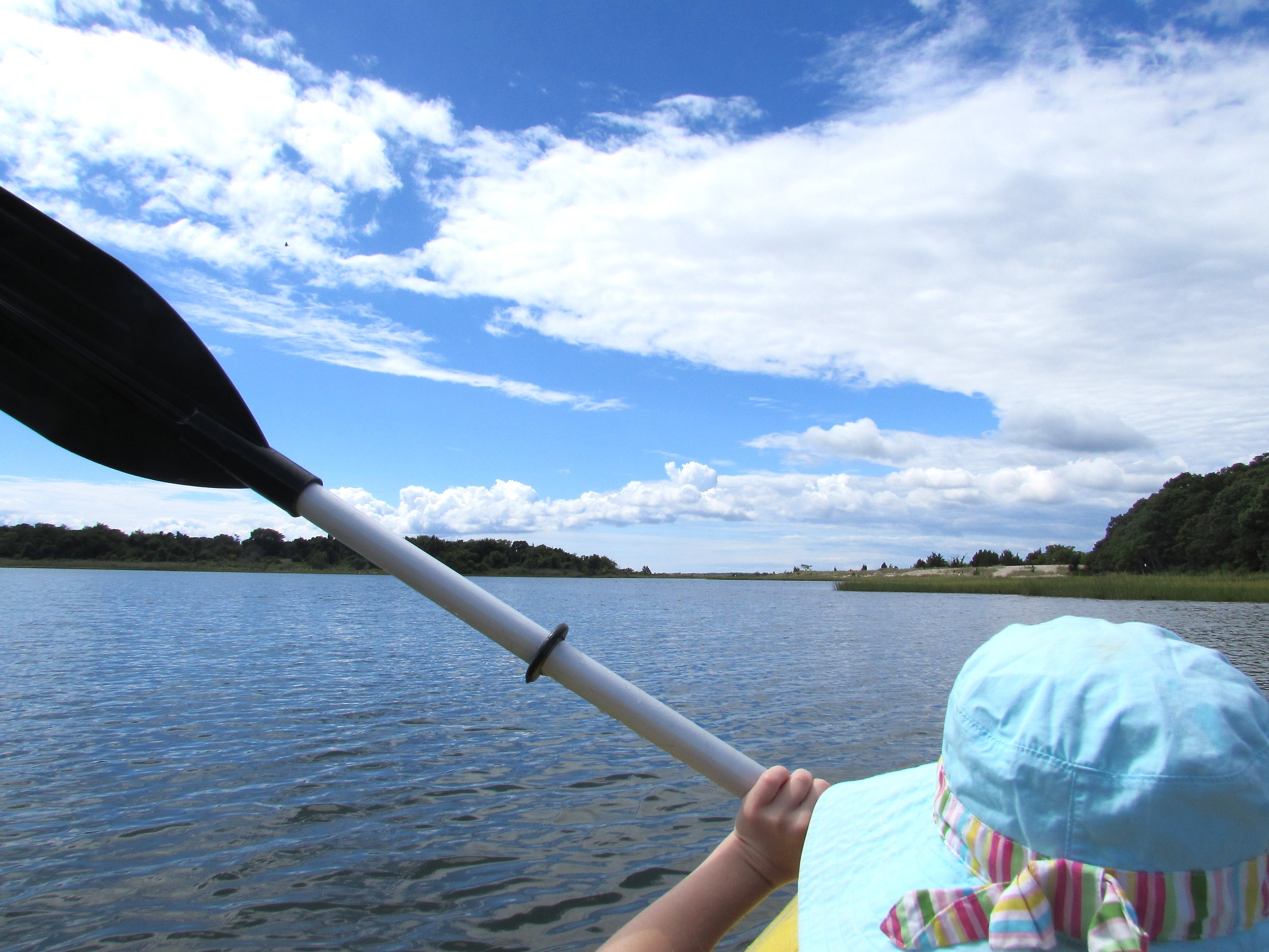
Jessup Neck by Kayak
Excerpted From Exploring East End Waters: A Natural History and Paddling Guide by Mike Bottini
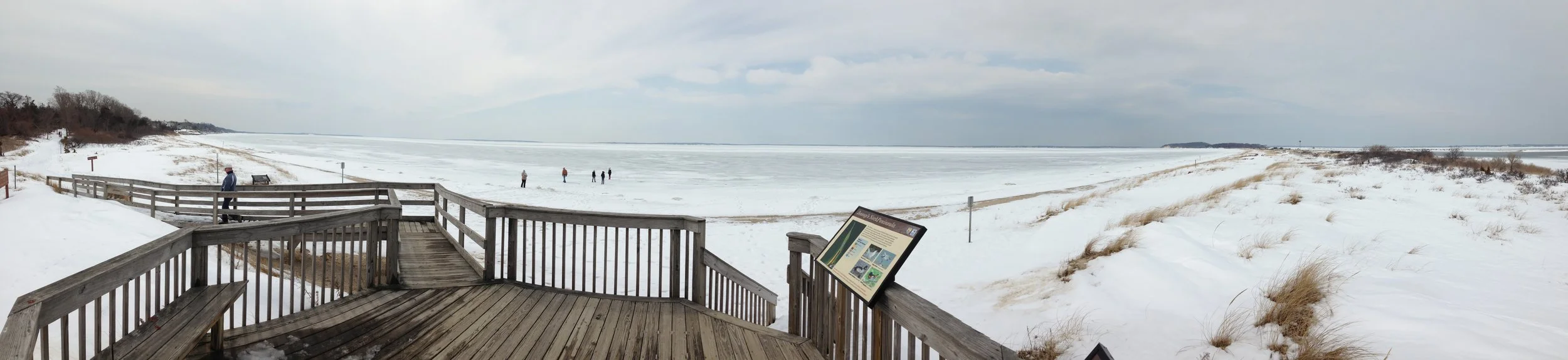
No more than three hundred yards wide and nearly two miles in length, Jessup Neck is a long ribbon of land undergoing continual metamorphoses that, unlike ourselves, results in measurable increases in length and decreases in girth over time. The change has been slow but dramatic. The three conical hills of glacial deposits that comprise the bulk of Jessup Neck today were once islands. In his book, Eastern Long Island Geology, geologist Les Sirkin refers to the Neck’s conical hills as kames, landforms of stratified outwash created by meltwater flowing off glacial ice or into a crevasse in the ice. Over the course of many thousands of years, wind, tide and littoral currents redistributed some of the material into a series of interconnected spits, called tombolos, that harbor salt ponds, marshes and lagoons. There is no better way to see and sense this process than by paddling along the shoreline of the peninsula.
Donated to the U.S. Fish and Wildlife Service in 1954 by Elizabeth Morton, this popular 187-acre preserve is one of only eight National Wildlife Refuges on all of Long Island. One of the best launch sites to explore the area is located at the end of Cedar Point Lane, which abuts Noyac Creek.
The entire wildlife refuge is second growth forest with an unusual mix of ornamental, non-native plants, reflecting a long and interesting history of agriculture dating back to the 1600s. Originally named Farrington Point for John Farrington, one of the founders of the South Hampton Colony, the peninsula took its current name from another of the newcomers from Lynn, Massachusetts that first settled in this area, John Jessup.
Jessup was deeded the neck in 1679 and, through the ensuing 275 years, ownership was transferred to only two other families. Jessup’s daughter, Abigail, was buried on the east side of the neck in 1724. On a canoe outing with Richard G. Hendrickson in 1994, we looked for the gravestone but could not locate it.
In 1800, Isaac Osborn acquired the land and began experimenting with a variety of crops and livestock, including mulberry trees for raising silkworms and introducing the first shorthorn cattle and merino sheep to Long Island. During this time, the entire area was cleared and either under cultivation or used for pasturing livestock. Even the salt marsh was periodically mowed. These grasses, collectively called salt hay, were used as winter fodder for the cattle and sheep.
The northern point of Jessup Neck was host to an international canoe regatta at the turn of the century. Paddlers from the U.S. and Canada, and their craft, were dropped off by steamship and camped near the point, where a well and hand pump provided fresh water. Participants demonstrated their skills in races and other competitions in Noyac Bay.


